What actually happened
Most visitors arrive knowing there was an earthquake. The sequence matters, because it explains why the city looks the way it does.
On 4 September 2010 a magnitude 7.1 earthquake struck near Darfield, west of the city, at 4.35am. It was large, it did substantial damage — and, because it happened before dawn on a Saturday and the epicentre was rural, nobody died. Christchurch spent the following months believing it had got away with it.
On 22 February 2011 at 12.51pm, a magnitude 6.3 aftershock struck almost directly beneath the city at very shallow depth. It was smaller on the scale and far more destructive in effect: shallower, closer, and it hit at lunchtime on a working Tuesday. 185 people died. The CTV building collapsed and burned, killing 115. The Pyne Gould building collapsed, killing 18. Masonry falling from facades killed people in the street and on two buses.
The ground itself failed in places. Liquefaction — where saturated silt loses strength under shaking and behaves like a liquid — pushed grey sludge up through lawns, roads and floors across the eastern suburbs. Some land was so damaged it was zoned unbuildable, and around 8,000 homes in the eastern "red zone" were eventually cleared. That land is now the Ōtākaro Avon River Corridor, a long green ribbon where streets used to be.
Aftershocks continued for years. Roughly 70 per cent of the central city's buildings came down, whether in the quakes or in the demolition that followed.
How to read the city now
Fifteen years on, the centre is not a ruin and it is not finished. It is something less common: a city where you can see the decisions being made.
Three things become obvious once you know to look for them.
The gaps are deliberate. Christchurch has far more open space in its centre than a city this size would normally have, because the rebuild plan capped the core's footprint and pushed green space through it. What reads at first as vacant lots is, in a good deal of cases, planned.
The new buildings are low. Post-quake building standards and a general loss of appetite for height mean the centre is mostly three to seven storeys. It gives the city a horizontal, light-filled feel that Auckland and Wellington do not have.
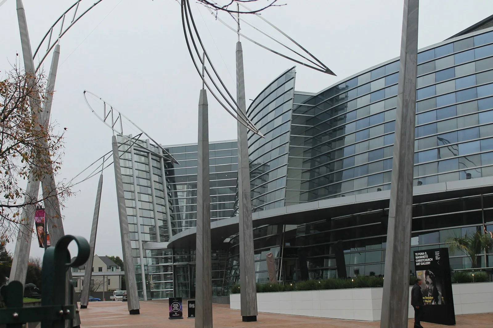
Base isolation is everywhere. Many new civic buildings sit on bearings that let the structure move independently of the ground. The Christchurch Art Gallery, retrofitted after the quakes, is one. You cannot usually see it, but it is why the city can build in the centre at all.
The walk, stop by stop
Two to three hours on foot, flat the whole way, and it can be done in either direction. Start at the Bridge of Remembrance. The order below runs roughly west to east and ends somewhere you will want to sit down, which is deliberate — the middle of this walk is heavy and the end should not be.
1. Bridge of Remembrance and Oxford Terrace
The 1924 war memorial bridge over the Avon, badly damaged and since restored. It is a useful place to start because it survived — a reminder that the story is not only loss.
2. Cathedral Square
The Square was the city's centre of gravity for 150 years and has been its unresolved question for fifteen. Stand in it for a minute before reading on: the emptiness is the point, and it is the one place on this walk where what is missing is more informative than what is there.
Christ Church Cathedral lost its spire on 22 February and the western wall later. It then sat in argument for a decade: demolish, restore, or replace. Reinstatement was finally agreed and work is ongoing, which means what you see is a cathedral mid-repair inside a construction envelope. For many locals the Square is still the unresolved centre of the whole thing.
3. Transitional Cathedral
Cardboard is not a joke here. The tubes are laminated, waterproofed and load-bearing, and the building was engineered for a fifty-year life rather than a season. Ban has built versions of this idea after disasters in Japan, Turkey and Haiti, and Christchurch has the largest.
Five minutes east on Hereford Street, the so-called Cardboard Cathedral — designed by Japanese architect Shigeru Ban, who specialises in disaster architecture, and built from 98 cardboard tubes, timber and polycarbonate. Opened in 2013 as a temporary replacement, it is still in weekly use. Go inside; the light through the triangular gable is the point.
4. 185 Empty Chairs
Across the road, an artwork by Peter Majendie: 185 chairs, each different, each painted white — a dining chair, a wheelchair, a baby capsule. One for every person who died. It was meant to be temporary and has stayed because people would not let it go. It is the most affecting thing in the city and takes about four minutes.
It is a memorial, not an installation. Quiet voices, and think about whether a photograph is the right instinct.
5. Oi Manawa — Canterbury Earthquake National Memorial
Back on the river, a curved marble wall along the Avon carrying the names of the 185, opened on the fifth anniversary in 2016. The name means "tremble of the heart". The riverside setting was chosen deliberately over a monument in a square.
6. Te Pae and the Convention Centre precinct
North across the river, the convention centre that anchored the commercial rebuild. Worth two minutes for the contrast: this is what the recovery looked like as public investment rather than as memorial.
7. New Regent Street
Every building on it was damaged and every building was kept.
A short pastel Spanish Mission terrace from 1932, restored after severe damage, and now one block of continuous cafes with the heritage trams running through it. This is the counter-argument to the idea that everything old was lost.
8. The Terrace and the riverbank
Finish on the south bank of the Avon where bars and restaurants now front the water. Ten years ago this was rubble. It is the most straightforwardly cheerful part of the walk and a good place to stop.
Street art, gap fillers and the transitional movement
The most interesting thing about the Christchurch rebuild is not the buildings. It is what people did with the space while there were no buildings.
Gap Filler, founded weeks after the September 2010 quake, put temporary projects into cleared sites — a pallet pavilion, an outdoor cinema, a dance-o-mat run off a converted washing machine. Greening the Rubble made pocket parks. The umbrella term that emerged, transitional architecture, has since been studied by cities worldwide facing their own recovery.
Alongside it came the murals. Christchurch has one of the densest concentrations of large-scale street art in Australasia, much of it from the SPECTRUM festivals, on walls that were exposed when the building next door came down. Works by Rone, Askew One, Owen Dippie and international artists are scattered through the centre, and a self-guided trail map is available from the i-SITE.
Some of it is temporary by design. A mural on a wall that was never meant to be seen disappears when the next building goes up, and that impermanence is understood as part of the work rather than a loss.
Why the city looks the way it does
Two decisions shaped the Christchurch you walk through, and both are visible once you know them.
The Blueprint
In 2012 the government published a recovery plan for the central city that did something unusual: it shrank the core deliberately. Rather than rebuilding the same footprint, the plan drew a compact frame around a smaller centre and ringed it with green space — the East Frame, the North Frame, and the Avon corridor. Anchor projects were designated: a convention centre, a stadium, a library, a justice precinct.
The effect is a centre that feels smaller and greener than the pre-quake city, with the retail core concentrated rather than spread. Some of it worked quickly and some took a decade, and locals will give you a range of opinions about which is which.
Building for the next one
The other decision was structural. New buildings here are engineered to a standard that assumes another major earthquake, and the visible consequences are everywhere: base isolation under civic buildings, exposed steel bracing used as a design feature rather than hidden, and a general preference for low-rise. Tūranga, the central library opened in 2018, is the best single example — five storeys, heavily glazed, and one of the busiest buildings in the city.
There is a quiet argument in this that visitors often miss. Christchurch could have rebuilt what was there. It largely chose not to, and the result is the most contemporary city centre in New Zealand — which is either the silver lining or the loss, depending on who you ask.
The eastern suburbs and the red zone
The walk above covers the centre. The part of the story that the centre does not tell is what happened east of it, and it is worth understanding even if you never go there.
The eastern suburbs sit on old swamp and river silt, and that is where liquefaction did its worst. Around 8,000 homes were eventually designated a residential red zone — land too damaged to rebuild on economically. Residents were bought out. The houses came down. Streets, driveways and letterboxes remained for years with nothing behind them.
That land is now the Ōtākaro Avon River Corridor, roughly 600 hectares of regenerating green space following the river out toward the estuary. It is being developed as a park, a native planting project and a cycle route, and the transformation from suburb to reserve is unlike anything else in the country.
You can cycle or walk it. The Coastal Pathway runs from Ferrymead toward Sumner, and the river corridor connects the centre to New Brighton. What is striking is how ordinary it looks now — mown grass and young natives — and how the street patterns are still faintly legible underneath.
The reason to mention it: the recovery in the east was slower, poorer and less photographed than the recovery in the centre, and it is a live subject in the city. A visitor who knows that is better company than one who only saw the new buildings.
Visiting respectfully
This is the part most guides skip, and it matters.
185 people died here in living memory. A great many of the people serving your coffee were in this city on 22 February 2011, and a fair number were in the buildings. The subject comes up naturally and locals will often talk about it openly — but let them raise it. "Where were you?" is a heavier question than it sounds.
At 185 Empty Chairs and Oi Manawa, behave as you would at any memorial. Photographs are not forbidden and plenty of people take them; the thing to avoid is treating either as a backdrop.
Be careful with the word "ruins". Sites still standing damaged are, in most cases, buildings someone is still arguing about or still repairing. And avoid framing the rebuild as finished — locals are sharply aware that the eastern suburbs recovered far more slowly than the centre, and that insurance disputes ran for a decade.
The good news is that Christchurch is not solemn about itself. The city is funny about the rebuild, impatient with it, and quietly proud of what came out of it. Follow that lead.
Beyond the walk: where the rebuild story continues
Four places extend the walk if it has caught your interest, and each adds something the street-level route cannot.
Quake City
A dedicated exhibition run by Canterbury Museum: survivor testimony, objects recovered from the rubble, the cathedral's fallen rose window, and a straightforward account of what the shaking actually did. It is the honest place to go if you want to understand rather than look. Allow an hour and expect it to be a hard one.
Tūranga, the central library
Opened 2018, five storeys, and among the busiest buildings in the city. Go to the upper floors for the view across the rebuilt centre and Cathedral Square — the best free vantage point in Christchurch, and a working demonstration of what the Blueprint was aiming at.
The Botanic Gardens and Hagley Park
Barely touched by the earthquakes, and that is precisely why they matter. Through the worst of it Hagley Park was where people gathered, and the Gardens are the continuity the centre lost. Twenty-one hectares of collections inside a loop of the Avon, and free. See the Garden City parks and punting.
Lyttelton
Over the Port Hills, the port town closest to the September 2010 epicentre and very badly hit — it lost much of its historic main street. The recovery there has been community-led and small-scale rather than master-planned, which makes it an instructive contrast with the centre. The Lyttelton Farmers Market on Saturday mornings is the best in Canterbury, and the tunnel or the Bridle Path gets you there in twenty minutes.
Practical notes
Doing it guided
The walk works perfectly well self-guided with this page. What a guide adds is the part that is not written down: which building stood where, what the argument over the cathedral actually turned on, and in many cases a personal account of the day. Several Christchurch guides were in the city on 22 February, and that changes the walk substantially. Ask when booking whether the guide is a local — on this particular subject it matters more than usual.
How long, and when
Two to three hours at a walking pace with stops. Mornings are quieter at the memorials. The whole route is flat and paved, and accessible throughout — Oi Manawa, the Transitional Cathedral and New Regent Street all have level access.
Getting around
The centre is small enough to walk end to end in twenty minutes. The heritage tram runs a loop through the rebuild precincts with commentary and is genuinely useful for orientation rather than just a novelty. See getting around Christchurch.
A note on the trams
The heritage tram loop is not a museum piece running on a token route — it threads the actual rebuild precincts, and the driver commentary is genuinely informative about what was demolished and what replaced it. A day pass lets you hop off, which turns the walk above into a much easier afternoon for anyone who would rather not do three hours on foot.
Where to go next
The Canterbury Museum and the Christchurch Art Gallery both address the quakes in their collections. Quake City, run by the museum, is a dedicated exhibition with survivor testimony and objects recovered from the rubble — the honest place to go if the walk leaves you wanting more, and a hard hour.
Combining it with the rest of the city
The walk pairs naturally with a punt on the Avon or an hour in the Botanic Gardens — both start within a few minutes of where it finishes, and both are the deliberate antidote to the heavier half. If you have a full day, the standard shape is rebuild walk in the morning, gardens and punting after lunch, gondola or Sumner in the late afternoon.
With children
The walk works for older children who have some context. For younger ones, the Botanic Gardens and the punting are a better use of the morning — see Christchurch for families.
The Ōtautahi rebuild: a walking guide: your questions
The September 2010 magnitude 7.1 quake caused major damage but no deaths. The February 2011 magnitude 6.3 aftershock was smaller but far shallower, closer to the city and struck at lunchtime on a weekday: 185 people died and roughly 70 per cent of central city buildings were eventually demolished.
The centre has been substantially rebuilt and is not a ruin. What you will notice is unusual openness — the rebuild plan capped the core's footprint and pushed green space through it — and new buildings that are mostly three to seven storeys. Christ Church Cathedral is still under reinstatement. The eastern suburbs recovered much more slowly than the centre.
The Transitional Cathedral, designed by Japanese architect Shigeru Ban and built from 98 cardboard tubes, timber and polycarbonate. It opened in 2013 as a temporary replacement for the damaged Christ Church Cathedral and is still in weekly use. Free to enter, and worth going inside for the light.
An artwork by Peter Majendie: 185 chairs, each different, each painted white, one for every person who died on 22 February 2011. A dining chair, a wheelchair, a baby capsule. It was intended to be temporary and has remained because the city would not part with it. Treat it as a memorial rather than a photo stop.
Two to three hours at a walking pace with stops, and it is flat and accessible throughout. Add an hour if you go into Quake City, and another if the Art Gallery has something on.
Not if you go the way you would to any memorial. Christchurch is open about what happened and the memorials exist to be visited. What lands badly is treating damaged buildings as ruins to pose in front of, or asking residents where they were that day before they raise it themselves.
Saturated silty ground losing strength under shaking and behaving like a liquid, pushing grey sludge up through lawns, roads and floor slabs. It devastated Christchurch's eastern suburbs, left around 8,000 homes in a residential red zone, and that cleared land is now the Ōtākaro Avon River Corridor.
Not as a visitor attraction. Reinstatement work is ongoing and the building sits within a construction envelope. You can see it clearly from Cathedral Square, and the Transitional Cathedral five minutes away is open and free.
A creative initiative founded weeks after the first earthquake that put temporary projects into cleared sites — a pallet pavilion, an outdoor cinema, a dance floor run off a converted washing machine. It is the best-known part of Christchurch's transitional architecture movement, which cities facing their own recovery have since studied.
Yes, and for reasons that have nothing to do with disaster tourism. It is the South Island's main gateway, the TranzAlpine departure point, the base for Akaroa and Kaikōura, and it has more genuinely new architecture and street art than anywhere else in the country. See our Christchurch travel guide.
Scattered through the central city on walls exposed by demolition, much of it from the SPECTRUM festivals. A self-guided trail map is available from the i-SITE. Some works are temporary by design and disappear when the next building goes up.
If the walk leaves you wanting to understand rather than just look, yes. It is a dedicated exhibition run by Canterbury Museum with survivor testimony and objects recovered from the rubble. Allow an hour, and expect it to be a hard one.