Getting around Toowoomba
Toowoomba is an easy drive from Brisbane and a compact, walkable city once you arrive — but the Darling Downs beyond it is spread out. Here's how to get up the range from Brisbane, whether to fly or take a coach, and how to get around the city and region once you're here.
Driving, coach & air
By car, it's about 125–130 km and 90 minutes to two hours from Brisbane via the Warrego Highway, climbing the range into the city. The tolled Toowoomba Bypass speeds through-traffic (or take the free, scenic old range road). Prefer not to drive? Greyhound and Murrays coaches run daily from Brisbane (around 1 hr 45 min), and Wellcamp Airport has QantasLink flights to Sydney plus Rex regional services — though for most visitors, Brisbane is the practical air gateway.
On foot, by bus & parking
The city centre is compact and walkable — you can stroll between Queens Park, the CBD cafés and the street-art laneways with ease, and parking is far less stressful than on the coast. The local bus network (on Queensland's 50-cent flat fares) covers the main corridors, but coverage is limited and weekend services are sparse, so it's handy rather than comprehensive. For getting about town, walking plus the odd short drive works well.
Touring the Darling Downs
To explore the wider Darling Downs — Crows Nest, Jondaryan, Ravensbourne, the Lockyer Valley and the Granite Belt — you'll really need a car, as public transport between the towns and attractions is minimal. Roads are generally good, but watch for wildlife and fog on the range. If you'd rather leave the driving to us, Cooee Tours' guided day and weekend tours cover the highlights with transfers from Brisbane and Toowoomba.
The Range crossing, in detail
Every trip to Toowoomba ends the same way: a climb. The city sits roughly 700 metres above sea level on the crest of the Great Dividing Range, and whichever road you choose, the last ten minutes of the journey involve hauling yourself up the escarpment that separates the Lockyer Valley floor from the Darling Downs plateau. From Brisbane the route is simple on paper — the Warrego Highway west through Ipswich, across the Lockyer flats past Gatton and Helidon, then up. The flat section is easy touring; the interesting part begins at the bottom of the range, where the highway starts winding through cuttings and the temperature gauge on your dashboard begins a slow, steady drop that will finish four or five degrees below wherever you started.
The climb rewards a little preparation. Trucks use this corridor heavily, the gradients are genuine, and overtaking opportunities are rationed, so build a buffer into your timing rather than trying to claw minutes back on the hill. Fog is the other local specialty: the range crest catches cloud, particularly on winter and early-spring mornings, and a clear run through Gatton can turn into hundred-metre visibility at the top. None of this makes the drive difficult — thousands of people do it daily without drama — but it is a proper highland approach rather than a freeway cruise, and treating it that way makes for a much calmer arrival in the Garden City.
Toowoomba Bypass or the old range road?
Since 2019 there have been two distinct ways up the hill, and they suit different trips. The Toowoomba Bypass — the 41 km tolled route already covered in the FAQ below — swings around the northern edge of the city with gentler gradients, dual carriageways and far fewer trucks grinding beside you. If you're towing, nervous about hills, travelling in fog season or simply passing through to the western Downs, the small toll is the easiest money you'll spend all trip. It deposits you on the western side of town, which also happens to be handy if your accommodation sits out that way.
The old Toowoomba Range road, by contrast, is the scenic, free and slightly theatrical option: steeper, tighter, and delivering you straight into the top of the city with glimpses over the Lockyer Valley on the way up. Arriving this way has a sense of occasion the bypass can't match — one minute you're climbing through bush, the next you crest the ridge and the Garden City unrolls in front of you. Our suggestion for first-timers: take the old road up for the arrival, and if the descent in the dark or the wet doesn't appeal, let the bypass carry you back down. You'll have sampled both crossings for the price of one modest toll.
Driving yourself vs taking a coach
The drive-or-coach question has a different answer depending on the month, and it's worth being honest about it. For most of the year, driving wins on flexibility: you can detour to a village bakery, linger at a lookout, and carry home as many nursery seedlings as the boot will hold. The road is good, the navigation is trivially easy, and parking in Toowoomba outside festival time is pleasantly low-stakes. If your trip involves the wider Darling Downs — and it should — a car turns the region's spread-out geography from a problem into a pleasure.
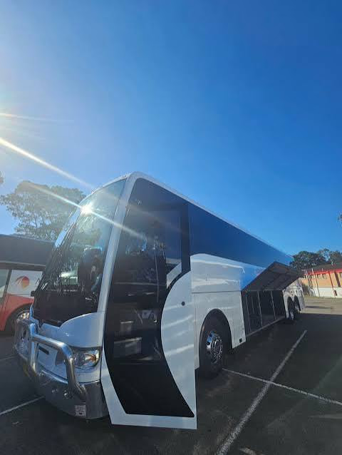
During the Carnival of Flowers, the maths changes sharply. In September the driver misses the best of the show: they're watching the road on the range while everyone else watches the view, then circling blocks near Queens Park while their passengers walk into the gardens. A coach removes the two most stressful parts of the day — the climb and the parking — and replaces them with a window seat. We've written up the full comparison, costs and all, in our driving vs coach tour guide; the short version is that self-driving suits shoulder-season flexibility, and the coach suits festival-season sanity.

Parking in September: what to actually expect
Toowoomba's parking is genuinely easy for eleven months of the year — this is a regional city with generous street parking, off-street car parks around the CBD and none of the coastal beach-suburb scramble. Then September arrives, the Toowoomba Carnival of Flowers fills the calendar, and the streets around Queens Park, Laurel Bank Park and the parade route turn into a competitive sport. On peak weekends — parade Saturday above all — expect to park several blocks from the big gardens, to walk further than you planned, and to see locals guarding driveways with the vigilance of border officials. It is cheerful chaos rather than gridlock, but it is real.
The workarounds are simple and worth taking seriously. Arrive early: before mid-morning the situation is manageable everywhere, and the gardens are at their best in soft light anyway. Park once and walk, rather than re-parking between gardens that sit ten minutes apart on foot. Check signage carefully around the parks, because event-day restrictions appear where none normally exist. And if the whole exercise sounds like a poor use of a spring Saturday, that's precisely the problem a coach day tour was designed to solve — you're dropped near the gates while the driver worries about all of the above.
Walking the CBD grid
Once you're in the city centre, the best transport is your own feet. Central Toowoomba is laid out on a compact nineteenth-century grid — Ruthven Street running north–south as the spine, Margaret Street crossing it as the dining and café axis — and almost everything a visitor wants sits inside a rectangle you can cross in about twenty minutes. Queens Park and the Cobb+Co Museum anchor the north-eastern corner, the street-art laneways thread through the middle blocks, and the heritage frontages along the main streets reward walking at exactly the pace driving prevents. Distances that look meaningful on a map turn out to be five-minute strolls.
Two practical notes make walking here even easier. First, the grid is mercifully flat — the city saves its slopes for the escarpment edge, so CBD walking involves none of the climbing the arrival did. Second, the blocks are long but legible: if you can keep track of Ruthven and Margaret you cannot really get lost, and the purple bloom of jacarandas in late spring or the Carnival plantings in September give you landmarks at every corner. Park the car once at your accommodation or a long-stay car park, and treat the centre as the pedestrian precinct it effectively is.

Accessibility: getting around with wheels, prams and walking aids
Toowoomba is a better city than most for visitors with limited mobility, largely because its showpieces are parks rather than trails. Queens Park and Laurel Bank Park both offer sealed, generously wide paths through their display gardens, with accessible parking nearby and level or gently graded routes to the best beds — a wheelchair or pram can reach the heart of the Carnival displays without heroics. The CBD's flat grid helps too: kerb ramps are widespread, distances are short, and the main visitor route between Queens Park, the museum precinct and the Margaret Street cafés involves no stairs at all.
The escarpment edge asks a little more care. The main lookout areas at Picnic Point are reachable on sealed paths close to parking, so the famous view over the Lockyer Valley is available to everyone; it's only the tracks dropping below the rim that demand sound knees. If you're relying on the local bus network, treat it as a supplement rather than a plan — services exist on the main corridors, but coverage is patchy and weekends are thin, so check current timetables before building a day around them. Travellers with access needs who'd rather not manage any of this will find coach touring the path of least resistance: one vehicle, door-to-garden logistics, and a seat with a view of the range instead of a fight with it.
Driving north: Highfields, Hampton and Crows Nest
The classic northern run is the New England Highway out of the city, and it's the gentlest day-trip drive on the Downs — a wide, well-kept road rolling through progressively prettier country. Fifteen minutes brings you to Highfields, the fast-growing village strip on the city's northern edge; another fifteen delivers Hampton on its cool ridge, where the highland air starts to feel properly different; and about forty-five minutes from the CBD you reach Crows Nest, a genuine country town with a village green, heritage shopfronts and a national park of granite gorges just beyond it. The route needs no navigation skill whatsoever: one highway, clearly signed, with the villages strung along it like beads.
Drive it as a loop rather than a beeline. The joy of this corridor is stopping — a bakery here, a gallery there, a lookout or picnic ground when the mood strikes — and the traffic is light enough that pottering is no imposition on anyone. Watch for wildlife at dawn and dusk, particularly on the tree-lined stretches past Hampton, and note that the ridge country runs several degrees cooler than Toowoomba itself, which in turn runs cooler than Brisbane; a jumper in the back seat is rarely wasted north of Highfields, even in spring.
Driving the eastern rim: Picnic Point, Spring Bluff and the valley floor
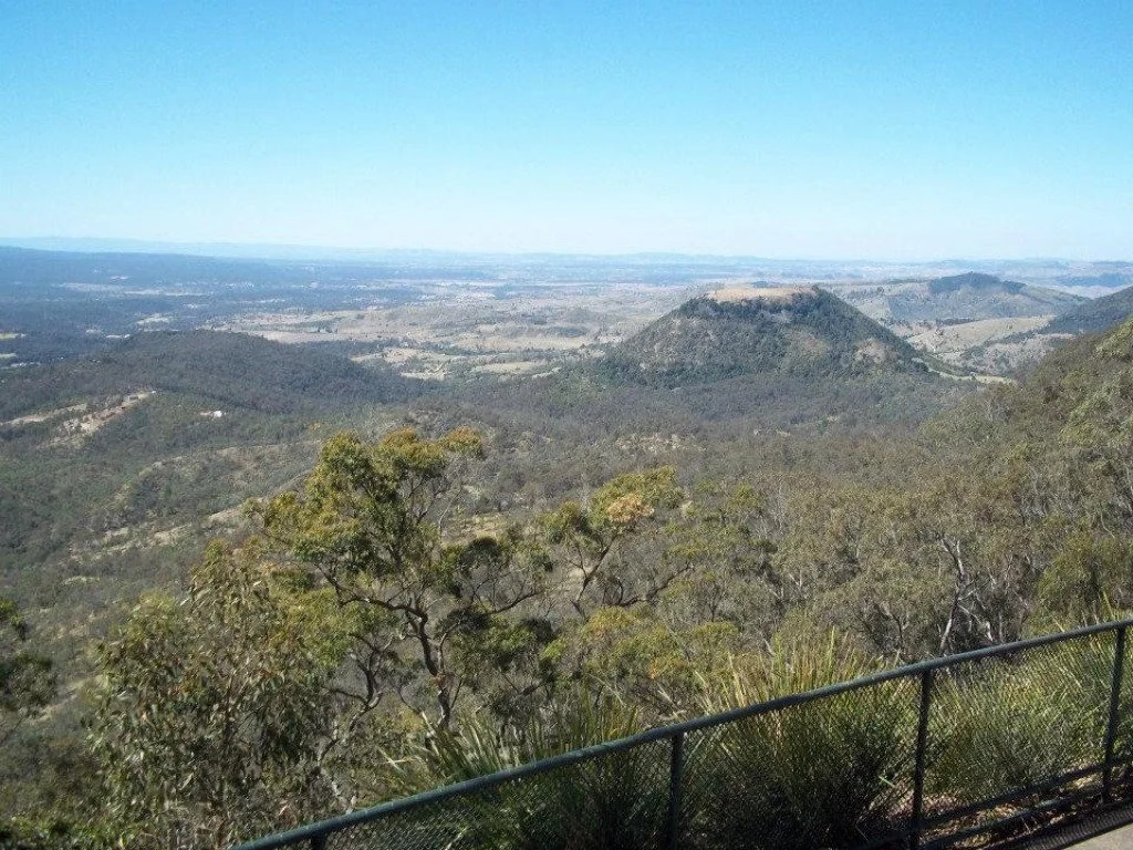
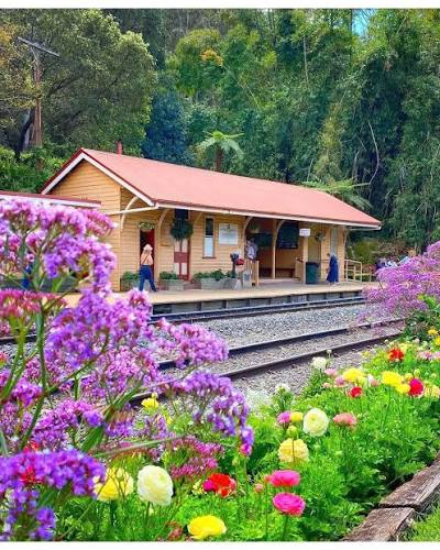
The shortest scenic circuit barely leaves town. Start at Picnic Point, ten minutes east of the CBD along the escarpment edge, where the lookout hangs over the Lockyer Valley and Table Top Mountain poses for photographs. From there the adventurous option is to drop off the rim: the back roads wind down the range toward Murphys Creek, and tucked into the folds partway down sits Spring Bluff railway station, the heritage siding whose platform gardens become one of the region's most photographed sights during the Carnival. The descent is steep, narrow in places and emphatically pretty — take it slowly, use the pull-offs, and accept that you'll be climbing every metre back up again.
During Carnival season, check access arrangements for Spring Bluff before you commit to the drive, as event-day traffic management can change how you get in and where you park; the station sits in a valley with finite room, and September finds its limits quickly. Outside festival time the eastern rim run is blissfully quiet — a morning's circuit of lookout, descent, station and return that shows you the 700-metre drop the city sits on better than any map could. It pairs naturally with breakfast at the top: view first, coffee after, valley floor for the adventurous middle.
Driving south and south-west: toward the Granite Belt
The long-haul option points south. The New England Highway in its southern direction carries you off the Downs proper and into steadily higher, rockier country, and if you follow it far enough you reach the Granite Belt — Queensland's high-altitude wine country, where boulder-strewn hills and cool-climate vineyards feel closer to New England than to the subtropics you left in Brisbane. This is a big day out from Toowoomba: allow a couple of hours' driving each way, which is entirely worthwhile for wine tastings and granite scenery but demands an early start and, crucially, a nominated driver who spends the day watching others enjoy the cellar doors.
That last clause is the honest catch with self-driving this corridor. Wine country and long country highways are a combination that punishes the person behind the wheel, and the distances rule out the casual half-day sampling that works closer to town. If the Granite Belt is a priority, either build it into an overnight stay so nobody is rushing the return leg, or hand the whole problem to a tour operator. Either way, fuel up before leaving Toowoomba, treat overtaking lanes as gifts rather than entitlements, and remember the southern high country gets properly cold — the region jokes about being Queensland's fridge for good reason.
How a Cooee coach day tour removes the whole problem
Everything above — the range climb, the fog windows, the September parking sport, the nominated-driver dilemma — is the case for letting someone else hold the wheel. Cooee Tours has been running coaches up this hill for decades, and our Carnival of Flowers day tours are built around exactly the pain points this page describes: pick-ups from Brisbane CBD and Chermside from $89 per adult ($69 per child), the roughly 1.75-hour run up the Warrego Highway handled by a professional driver, and drop-offs by the gardens while self-drivers are still hunting for parking. Gold Coast departures run from Helensvale ($99/$79) and Sunshine Coast pick-ups from Maroochydore and Caboolture ($109/$89), so the coach option works whichever corner of the south-east you're starting from.
The format scales with your appetite. A deluxe day tour at $159 including a two-course lunch softens the schedule for those who prefer their touring unhurried, add-ons like the Spring Picnic Lunch ($22) and premium front-of-coach seating ($5) tune the day further, and weekend tours from $595 turn the day trip into a proper stay with the driving handled in both directions. The quiet advantage nobody mentions until they've tried it: on a coach, the Range crossing becomes the scenic highlight it always deserved to be. You watch the Lockyer Valley fall away below the window, and arrive at the top having seen the view instead of the white line.
Evenings, dinner runs and getting back
Toowoomba's evening logistics are refreshingly simple, with one caveat. The dining precinct concentrates along and around Margaret Street, which means an evening out is a walking event if you're staying centrally — restaurant to bar to accommodation without touching the car keys, on flat footpaths through streetscapes that reward the stroll. Parking pressure evaporates after office hours outside festival season, so even visitors staying further out can drive in, park within a block or two of dinner, and forget about it. Taxis and rideshare operate in town for the nights that run long; availability is that of a regional city rather than a capital, so book ahead rather than gambling on the kerb at closing time.
The caveat is the range itself. If you're day-tripping from Brisbane in your own car, remember that the descent is waiting at the end of the evening — dark, sometimes foggy, and less fun after a long day than the morning climb was. Locals think nothing of it; visitors should at least think about it, and either start the trip home before fatigue sets in or, better, stay the night and give the city its evening. Toowoomba after dark, with dinner done and the streets quiet, is a far better final memory than headlights on the down-grade.
Our verdict: match the transport to the trip
Strip this page to a paragraph and it reads like this. For a flexible shoulder-season visit built around the Darling Downs villages, drive — the roads are good, the parking is easy ten months of the year, and the region's best moments hide down side roads a timetable will never find. For a September pilgrimage to the Carnival of Flowers, take the coach and pocket the difference in stress: the festival's hardest parts are the climb and the parking, and a day tour deletes both for less than many people spend on fuel and tolls. Within the city itself, walk — the grid is small, flat and best appreciated at footpath speed — and treat the local bus network as an occasional helper, checking current timetables rather than assuming coverage.
However you come, respect the hill and it will treat you well. Leave margin for fog, keep the tank and the phone charged for the country runs, arrive early at anything September-adjacent, and remember that the 700-metre climb that guards this city is also the reason it exists — the height brings the cool air, the cool air grows the gardens, and the gardens are why you're making the trip up the Toowoomba Range in the first place. Getting here is not an obstacle to the visit. Done right, it's the opening act.
Is there a train from Brisbane to Toowoomba?
Not in any practical day-trip sense. There is no commuter rail service up the Range — the suburban network ends in the Lockyer Valley — and only limited long-distance services pass through Toowoomba on set days (check Queensland Rail for current timetables if you're curious). For visitors, the realistic choices are the ones this guide covers: driving the Warrego Highway, a scheduled coach service, or a guided coach tour that turns the Range crossing into part of the experience. The heritage rail exception is a beauty, though — Spring Bluff station, halfway down the Range, occasionally welcomes special-event trains during the Carnival, and its platform gardens are worth the visit however you arrive.
Getting around: your questions
Most people drive — it's about 125–130 km west of Brisbane, roughly 90 minutes to two hours up the Warrego Highway and over the Great Dividing Range. The Toowoomba Bypass (a tolled 41 km road) lets through-traffic skirt the city. There are also daily coaches (Greyhound, Murrays) from Brisbane, and limited flights into Wellcamp Airport. See the options below.
Yes. The Toowoomba Bypass (officially the Toowoomba Second Range Crossing) is a tolled 41 km route that opened in 2019, carrying through-traffic and heavy vehicles around the city and down the range. The car toll is modest (around $2.88 as of mid-2025). If you'd rather avoid the toll, you can still use the older, steeper and more scenic Toowoomba Range Road into the city.
Yes, but limited. Toowoomba Wellcamp Airport (west of the city) has QantasLink flights to Sydney and Rex regional services (to Brisbane and western Queensland). There are no direct Melbourne, Cairns or Townsville flights, and schedules change — so check current timetables. For most visitors, driving from Brisbane (or flying into Brisbane and hiring a car) is the simplest option.
Not a practical one for most visitors. Queensland Rail's Westlander service stops at Toowoomba only twice a week each way and takes around 3.5 hours from Brisbane — it's a heritage/outback rail experience rather than a commuter link. There's no fast passenger rail (Inland Rail through the region is for freight). A car or coach is the way to go.
Within the compact city centre you can walk between the gardens, cafés and laneways, and the local bus network runs on Queensland's 50-cent flat fares (though coverage is limited, with little weekend service). But for the Darling Downs day trips — Crows Nest, Jondaryan, the Granite Belt — a car is essential. If you'd rather not drive, our guided tours cover the region with transfers included. See our day trips guide.